WISH ORE SUMMARY Jan 2023,
- Property is about 14km long by 3 km wide
- Located 60km north of Sault Ste Marie and 12 km from Trans- Canada highway. Excellent road access
- The geology and mineralization appears to be consistent with the newly developing Wawa Gold Corridor in the small Wawa Michipicoten greenstone belt to the north. We believe Wish Ore could be a similar situation of that mineralizing event in the Batchewana Greenstone belt.
- Underlain by Archean aged Batchewana greenstone belt
- Geology is comprised of mafic to intermediate volcanics, subvolcanic units, and some intermixed meta sediments
- Anomalous gold occurs along 5km strike length within a high strain zone that is >8km long and up to 300 m wide with three showings found to date.
- Within the high strain zone there are broad areas of quartz carbonate alteration with associated quartz veining.
- grab samples as high as 27 gpt Au
- Channel samples up to 9 gpt Au over 1 meter
- This past November four short holes in the high strain zone to assist the geologists to better understand the geology and structure. Broad areas, up to 40 meters thick, of anomalous gold values were intersected with a high value of 2.1 gpt over 1 meter.
- The data is being reviewed to try to understand the controls for the gold mineralization.
- From our 2021 airborne survey we will still be following up on the 19 Areas of interest.
Wish Ore Plans for 2023 include more drilling, possibly RC or modern percussion to reduce cost an expand coverage, as well a further structural mapping, prospecting, sampling and possible geophysics.
REGIONAL ACTIVITY
Just to northwest of Wish Ore
Stone Gold Inc. recently reported hitting copper mineralization from diamond drilling this spring near the former mine site, some 80 kilometres north of Sault Ste Marie. Results are still pending (January 06 2023 from the 4,000-metre diamond drill program that the company started in mid-April to determine the grade and the depth of the untapped resources that still remain.
The exploration outfit has put together a 21,000-hectare claims package of copper and gold prospects in the Batchawana Bay area on the eastern shore of Lake Superior, inland from Mamainse Harbour.
Two former copper mines are on Stone Gold’s Copper Road Project, the Tribag and the Coppercorp. Both operated in the 1960s and early 1970s until falling copper prices forced their closure.
Wawa Gold Corridor
Jan. 06, 2023 (GLOBE NEWSWIRE) – Red Pine Exploration Inc. (TSXV: RPX, OTCQB: RDEXF) (“Red Pine” or the “Company”) is pleased to report results from its continuing exploration program. Hole SD-22-396 intersected significant mineralization in the Surluga North Vein Network above the Jubilee Shear Zone (hanging wall) of the current resources of the Wawa Gold Project. All reported drill widths are core length unless otherwise stated.
- High-grade mineralization in the Surluga North Vein Network extended laterally to the north by 115 m
- Gold mineralization is associated with a network of multidirectional quartz-tourmaline veins
- The vein network is in the hanging wall of the Jubilee Shear Zone and was intersected at 165 m vertical depth
- Contains 5.13 g/t gold over 37.47 m, including 25.20 g/t gold over 3.41 m in SD-22-396 (see table 1)
- Other intersections of significance in the Surluga North Vein Network includes that have previously been released includes: 8.46 g/t gold over 6.42 m in SD-22-321
List of gold Companies in the Wawa Gold Corridor
From Junior Mining network https://www.juniorminingnetwork.com/mining-stocks/wawa-gold-corridor-mining-stocks.html
Alamos Gold (TSZ AGI)
Red Pine Exploration (TSX.V RPX)
Iamgold (TSX IMG)
Wesdome Gold Mines ((TSX WDO)
Argonaut Gold (TSX AR)
O3 Mining (TSX.V OIII)
Red Pine Exploration (TSX.V RPX)
Angus Gold (TSX.V GUS)
Manitou Gold (TSX.V MTU)
Argo Gold (CSE ARQ)
Bold Ventures (TSX.V BOL)
Kesselrun Resources (TSX.V KES)
Golden Goliath Resources (TSX.V GNG)
Kingsview Minerals (CSE KVM)
MacDonald Mines Exploration (TSX.V BMK)
Frontline Gold (TSX.V FGC)
RT Minerals (TSX.V RTM
The Wish Ore property lies within the developing Wawa Gold Corridor and is underlain by northeast trending meta sediments and meta volcanics of the Batchewana Greenstone Belt, with a major structure (Carp River Fault) running parallel to the trend. Anomalous gold values occur associated with a high strain silicified zone over 6 kilometers along and adjacent to the Carp River structure, which is cut by northwest trending lineaments. The intersection of the main structure with the northwest trending lineaments creates an attractive exploration target.
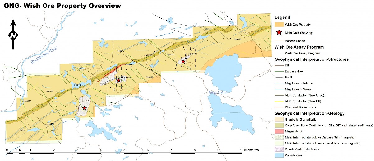
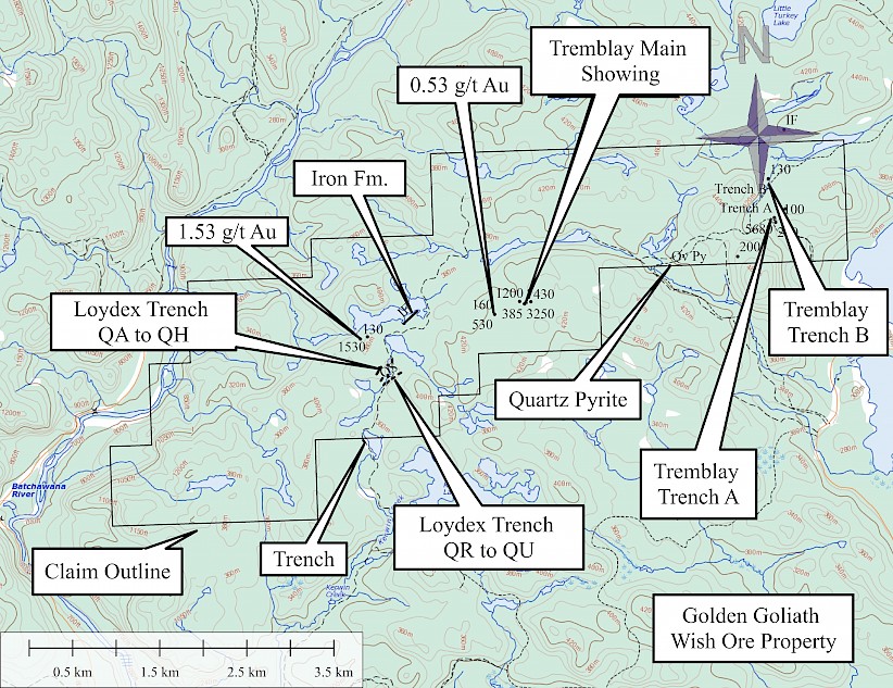
Several new shear zones were discovered on the property by prospector Mike Tremblay in 2013. The most promising of these was a new silicified zone in mafic volcanics south of the Carp River Fault from which grab samples assayed 1.2, 2.57, 8.8, 13.13, 13.73 and 25.57g/t gold. The shear zone is at least 30m wide, runs east-west and consists of silica, ankerite and sericite alteration. The best gold values were from a quartz-ankerite-pyrite +/- chalcopyrite vein that is at least 1m wide. Mineralization was also identified south of the fault zone associated with quartz-ankerite-pyrite stringers in a quartz feldspar porphyry assaying 1.53 g/t gold.
In the spring of 2014 logging operations exposed several carbonatized shear zones west of Upper Tilley Lake. Several anomalous samples were collected with a high value of 2.87g/t gold. The widest of these shears is over 30m wide and is exposed intermittently over 125m strike length.
Pictures taken during a site visit in May 2019 for a 43-101 Technical Report
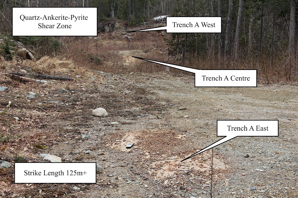
Regarding his site visit Wayne Holmstead P.Geo said this about Trench A
{The prospector} said there was no sign of any past work on this showing that was exposed by the logging company and most of the recorded work was west of here around the Loydex trenches. As well there are several parallel zones here that have not been cleaned off…very exciting.
Re Trench A West, Red lake expert Andreas Lichtblau MSc, P.Geo said:
“The Fe-carb alteration around the quartz veins is similar to what we have here in Red Lake. When the veins carry sulphides, especially arsenopyrite, then they’ll have gold. “
Phase 1 Work
Initial Evaluation work was designed to examine, manually strip and channel sample known gold showings on the property and was successful in identifying significant gold mineralization.
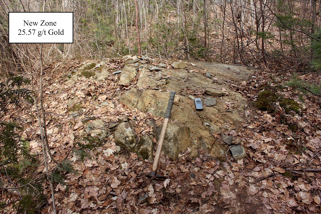
Values of 4.28 g/t gold over 3 meters including 9.05 g/t gold over 1.0 meter were identified from channel sampling on the New Zone. Now, Phase 2 mechanical stripping has revealed that the initial sampling did not include the entire zone of mineralization and subsequent sampling, which has already been completed, may reveal a wider mineralized zone than first anticipated. The Company awaits the assays. The gold mineralization was found to be associated with volcanic rocks with quartz veining and carbonate alteration. Low concentrations of sulphides and chalcopyrite mineralization were also noted.
Early work by Golden Goliath
-
Mechanical stripping, washing and channel sampling of known gold showings on the property
-
Prospecting to locate historical showings and undiscovered showings on the property
-
Geophysical surveying ( IP, MAG and VLF-EM) over known showings to define their extent and identify the geophysical signature of the showings.
-
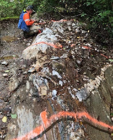
Mechanical stripping of the Loydex Zone (see Fig. 1) and the New Zone was done with a small backhoe and channel samples were subsequently taken. The samples are beinjg submitted to the lab for analysis. In addition, the other trenches done by Loydex in 1987 were located.
Loydex concluded that “two and possibly three zones of gold mineralization have been trenched” on the property. “Wide zones of carbonate alteration are associated with some of the pits as well as wide sections of gold bearing quartz veins in association with blue quartz eyed volcanics make the area attractive for further work.”
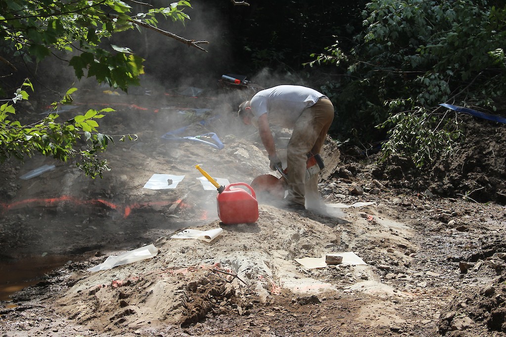 Figure 1: Channel Sampling Loydex Zone
Property prospecting has revealed large, angular, pyrrhotite and quartz mineralized boulders on a new logging road. The boulders are associated with a major northeast-southwest trending linear feature on the property and a coincident resistivity low from an airborne survey done by Lacana in 1988. Samples were collected and will be analyzed to determine if there are any metals of interest associated with the mineralized boulders. This represents a new, previously unexplored target on the property and will be followed up during Phase 3 exploration planned for September.
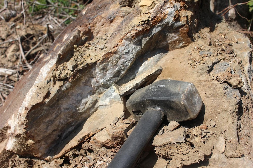 Figure 2: Large, angular, mineralized boulders found by prospecting.
2022 work
In early 2022 The Company received the interpretation on an airborne Mag and VLF EM survey interpreted by Peter Diorio, P,Geo. of GeophysicsOne Inc. Mr. Diorio identified 19 Areas of Interest (AOIs) for follow-up. While all of the anomalies look very encouraging, the most exciting of these are AOI 4 and AOI 8 which are located adjacent to known gold mineralization on the property at the Trench zone and the New Zone. AOI 1 and AOI 15 show large-scale potential as they appear to be associated with a 700 meter zone of interpreted flexure along the deep seated Carp River fault and the intersection of a northwest trending structure. AOI 13 is also an anomaly near the junction of the Carp River Fault and a northwest trending structure. Prospecting in 2019 identified large angular mineralized boulders 200 meters down ice southwest of this anomaly. In the underexplored southwest end of the property AOI 7 consists of an anomalous northwest trending mag low which cuts three east west trending mag highs. The area of the mag low is associated with VLF conductors and interpreted structures. This is interpreted to represent an area of alteration where magnetic minerals were destroyed by the alteration similar to what is seen in the areas of intense quartz carbonate alteration elsewhere on the property.
All of the high priority targets were then examined on the ground. On the west grid the mapping program extended the iron carbonate alteration package within the area of high strain east of the New Zone to the area of AOI 8. Numerous outcrops of Iron Quartz Carbonate were sampled. On the east grid the program extended the alteration package 500 meters along strike to the east between the Trench zone and anomaly 4. Locally intense iron carbonate alteration with extensive quartz veining with up to 5% pyrite and chalcopyrite was mapped and sampled along the trend. Northwest of the West Grid prospecting and mapping identified alteration and quartz veining in disrupted Iron Formation in close proximity to Iron Carbonate altered intermediate volcanics. The work has allowed Francois Berniolles, P.Geo. to update the geological and structural interpretation for the property.
Mr Berniolles concluded that two trends of mineralization and anomalous gold values have been located on the Wish Ore property. The northern trend adjacent to the northeast trending Carp River fault is associated with sheared and iron carbonate altered intermediate to mafic volcanics in contact with banded iron formation. The southern trend is parallel and hosts the high strain zone with associated quartz iron carbonate alteration of the intermediate to mafic volcanics. High gold values identified previously seem to occur localized within these two trends. Based on the geological mapping we believe there are previously unrecognized structural controls associated with the high gold values.
Analysis of the Geochem data set attempted to identify gold vectors that may assist the understanding of these structural controls. Plans for a preliminary drill program to test the known gold showings were then devised.
2022 Preliminay drilling
The purpose of this program was to do a preliminary drill test of the known showings to get a better understanding of the mineralization, geology, structure, and alteration associated with the known gold values. This preliminary drill program consisted of 4 diamond drill holes totaling 583 meters. The program targeted the two main showings on the property found to date within the high stain envelope and IP chargeability with coincident gold geochemical anomalies near the showings.
All four holes intersected sheared and altered mafic to intermediate volcanics with variable amounts of intermixed meta sediments restricted to the Trench Zone. The New Zone has shown encouraging quartz veining structures consistent with the ones mapped in the historical work, with sulfide content varied from trace to 5% associated with silicification and quartz carbonate alteration. The holes in the Trench Zone revealed interesting folded sections, with quartz carbonate veining in the hinge zone vicinities returning anomalous gold values, as well as deformed quartz chlorite carbonate veins associated with chalcopyrite mineralization.
Broad intersections of anomalous gold values were returned. Including 16m with a high of 0.388 gpt over 4 meters, 23m with a high of 0.885 gpt over 4 meters, and 15m with a high of 0.883 gpt over 6m all from W22-01. From W22-04 over 3km along strike to the northeast returned 41m with a high of 0.705 over one meter, and 23m with a high of 1.125gpt over one meter. Some of the best looking intervals seen in the logging process were found in W22-02. Hole two samples may have been compromised by a core shack fire despite the success of recovering representative samples from the drill hole.
Plans for the 2023 work on Wish Ore are currently being compiled but will include more drilling, possible air drilling to reduce costs and increase coverage, as well as further mapping , prospecting and sampling.
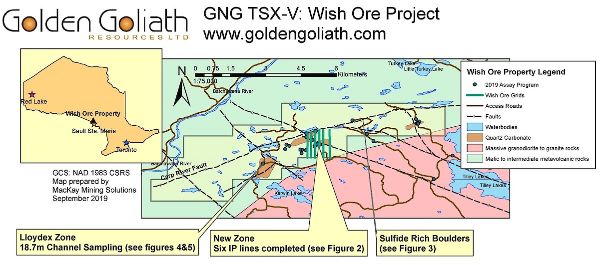 Figure 1: Wish Ore Property Map with IP grids and showings
Previous work by the Company on Wish Ore, conducted earlier this summer identified a new zone of mineralization with values of 4.28 g/t gold over 3 meters including 9.05 g/t gold over 1.0 meter obtained from channel samples cut on exposed outcrop August 22 GNG Press Release. Phase 2 mechanical stripping then revealed that the initial sampling did not include the entire zone of mineralization and subsequent sampling, which has already been completed, may reveal a wider mineralized zone than first anticipated. The Company awaits the assays. The gold mineralization was found to be associated with volcanic rocks with quartz veining and carbonate alteration. Low concentrations of sulphides and chalcopyrite mineralization were also noted.
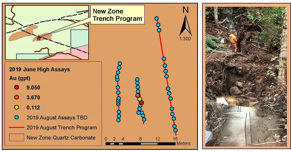 Figure 2: New Zone and Subsequent 23m Channel Sampling Program, August 2019 (Assays Pending)
Subsequent prospecting on the property has also revealed large, angular, pyrrhotite and quartz mineralized boulders on a new logging road. The boulders are associated with a major northeast-southwest trending linear feature (Carp River Fault) on the property and a coincident resistivity low from an airborne survey done by Lacana in 1988. Samples were collected and are being analyzed to determine if there are any metals of interest associated with the mineralized boulders. This represents a new, previously unexplored target on the property and will be followed up during Phase 3 exploration planned for September.
In addition, the historical trenches by Loydex Resources Inc. were located by prospecting. Historical gold values of up to 0.294 oz/ton (10.1 g/t) in grab samples have been reported here in quartz-carbonate, mineralized outcrops. One of the areas reported by Loydex was recently mechanically stripped by the Company and 18.7 meters of channel sampling was done. Analyses are pending.
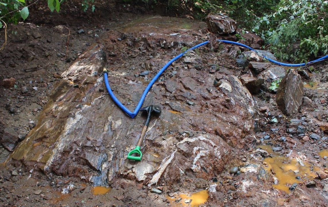
Figures 4 & 5: 18.7m Channel sampling and Quartz-Carbonate Alteration on Lloydex Zone (Assays Pending)
Company CEO Paul Sorbara says, “We already have multiple drill targets on the Wish Ore property and there is still a lot of potential to be evaluated. One of the Induced Polarization targets covers an area with Iron Formation and needs to be prospected, sampled and possibly stripped in that area. The trend of the nearby Carp River Fault needs to be thoroughly examined. Between the exciting results on our Kwai and SLF properties in the Red Lake area August 27 GNG Press Release and now Wish Ore near Sault Ste Marie, there will be a lot of drilling in our future.”